Following the global trend and emerging practices, Nepal is making continuous progress in implementing cutting-edge technologies in Humanitarian Response and Disaster Risk Reduction. The process is simultaneously supported and championed by the diverse range of partners and stakeholders involved in the development, sensitization and adoption of such technologies in the local context. One such popular and useful technology, which is slowly gaining momentum in its usage in Nepal is Drones, also known as Unmanned Aerial Systems (UAS).
UAS refers to a system including an uninhabited flying vehicle that is operated by the pilot based on the pre-entered program and/or on its own recognition of the surroundings. They can be remotely controlled, semi or fully autonomous, or a combination of any of the above modes of operations. The UAS is not just a tool for beautiful aerial photography but is a flying device with the capacity to carry out different types of aerial missions and payloads capturing accurate and detailed high-resolution images and spatial data from the ground and with the ability to use it as a lightweight cargo. The major type of payload includes cameras, multispectral sensors, cargo boxes, etc. Due to their portability, agility, ever-advancing technology and ever-increasing accessibility, UASs are increasingly becoming popular and seeing widespread use by relevant professionals and practitioners every now and then.
Since the Gorkha earthquake in 2015, the application of UAS in Nepal is gradually growing. The UAS is now frequently used by different sectors like; private, academic, tourism and entertainment industries for different purposes of their interest. More commonly, the UAS is used for activities like; aerial photography and videography, topographical surveying & mapping, glaciological research, surveillance and traffic monitoring, emergency preparedness and response and so on. The increase in the popularity of UAS among people and authorities has led to better acceptance of drones, and their utility in different phases of disaster risk reduction and resilience building. With the release of more systematic UAS guidelines by the Ministry of Home Affairs in 2019, the application of this technology is becoming more prevalent across several sectors particularly for the following major reasons:
1 Whether optical images or multi-spectral, as the UAS flies close to the earth's surface and hence they can capture aerial images of high spatial resolution and quality.
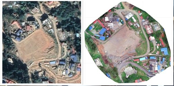
Left Google Earth Image, Right Image UAS High Resolution.
2 UAS is a quickly deployable and cost-effective technology as it does not require any major logistical and technical setup, unlike other options. Furthermore, they can be frequently flown, and offer higher temporal accuracy.
3 UAS can fly above risk areas with ease in disaster-affected regions supporting better planning of humanitarian assistance by mitigating the level of risks to emergency responders
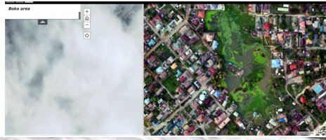
4 UAS can fly below the clouds and its capacity is unaffected by the cloud coverage, which makes it more popular and effective.
5 Unique viewing angle: Drones can fly very close to damaged structures. Some drones with exoskeleton hardware, can even go inside a building and capture data. They can provide unique viewing angles that may not be possible from manned aircraft.
Figure 2: Left(Satellite Image-Cloud Cover), Right (High-resolution Image by UAS on the same day) - Tanzania Flood 2017, Image Source: Tanzania Flying Labs
POSSIBLE APPLICATIONS OF DRONES IN DRRM
Every year Nepal faces a number of disasters: floods, landslides, windstorms, fires, snowstorms, etc. These incidents result in the loss of hundreds of lives and billions of Nepalese rupees. Frequent disasters in difficult terrain make disaster risk management a daunting task in Nepal. However, it is not only limited to the hazards; the increasing urbanization, haphazard growth, changes in the land use pattern and poor infrastructure planning have also resulted in the increase of vulnerability and exposure component; thereby imposing a serious disaster risk. These components have thus aggravated the challenges in disaster risk reduction and implementation of effective response strategies. In this regard, accurate and up-to-date geo-information is very critical and indispensable. Though there are some instances of technology adoption, the Rapid Response Teams of the Government of Nepal still rely on conventional ways of gathering the necessary information in post-disaster response. In this context, UAS can enable highly portable and quick-to-deploy alternatives for situational awareness to aid with efficient disaster planning, response and management activities.
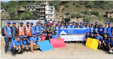
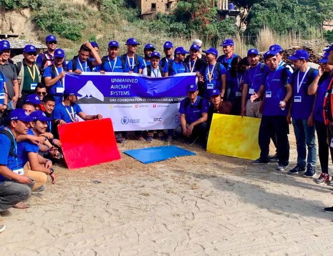
Disaster Simulation training on UAS Coordination in Humanitarian Action September 2019, 40+ government officials from different agencies participated in the five-day workshop
For any kind of hazards or disasters, UAS can be used in all phases of the disaster i.e. pre-disaster, during and post-disaster. Some of the priority usages of drones in all three phases are as follows:
PRE-DISASTER
● High-resolution data and images captured from drones and outputs generated utilizing drone images such as Digital Elevation Model and Orthophoto maps, which are useful for a number of hazard mapping and modelling related activities. Eg: high-resolution DEM from drones can be used in precise flood and landslide modelling works.
● Highly accurate maps from high-resolution UAS images can be used to accurately map the utilities, road networks, and other geographic objects so that authorities will have an accurate and updated baseline dataset of capacities for better emergency preparedness planning.
● High-resolution images could be utilized to identify and map safe and open spaces for humanitarian purposes particularly in dense urban areas.
● High-resolution images from drones and outputs from them such as point clouds and DEM could be used in high accuracy risk modeling and risk profiling works.
● Point clouds datasets of any area and optical images produced by UAS can be used to prepare a geomorphological map which could be later used to extract morphological features.
● The orthoimages and videos obtained from the drone can be subjected to the Spatio-temporal analysis of the study area. This can contribute to the study on changes of Land Use Land Cover analysis, and so on.
DURING -DISASTER
● Drones can fly very close to the ground surface, thus they can be used for Surveillance purposes. It will thus
● In areas with complex terrains, topographies, serpentine roads, and hard-to-reach areas, drones can be a suitable alternative to transport and supply small packages of relief items like medicine, test samples, and other essential goods.
● Deployment of Drones can also help in the real-time assessment of the disaster scenario and can thus help the decision-makers to plan for effective response.
● Both in disaster scenarios or with more common search and rescue missions, it's important that missing persons are found as soon as possible to maximize their chance of survival. The drones cover multiple acres of land in a very quick time and therefore provide a full and detailed view of the terrain which helps to speed up the search and rescue mission.
● For journalists, drone images and videos are the best support for drafting a true and live story. They can show the extent of damage and seriousness of the situation through high-resolution photos and videos.
POST-DISASTER
● Drones can be deployed for the Initial Rapid Assessments (IRA) to quickly understand the ground scenario.
● Drones can also be deployed for various assessments like the assessment of the impacts of a disaster, Damage and Loss Assessment (DaLA), Post Disaster Needs Assessment, and so on.
● Drone mapping not only creates an immediate record of damage after an emergency, but it also helps to conceptualize the damage in a more operational way during the recovery and reconstruction planning phase.
Recent Examples of Use of Drones in DRRM
Right after the Nepal Earthquake 2015, an unprecedented number of small and lightweight UAS was flown by a vast range of journalists and humanitarian responders. The majority of the journalists flew drones to capture aerial contents for the media while several humanitarian responders used it for rapid damage assessment and tested its application to provide better information for reconstruction planning. Globally, drones have been used in a range of different emergency situations and humanitarian settings. The National Disaster Management Authority in India has already carried out a scoping study on the Role of UAVs in Disaster Management. Later in early 2021, the Indian authorities used drones and a range of several other technologies such as radars and remote cameras to assess the ground situation, plan rescue operations and look for missing people in a situation of heavy floods.
In 2017, UAV helped search and rescue crews to locate a group of five missing persons (snowboarders and skiers) at Ski resort in British Columbia. Likewise, the U.S. Fire Administration has been using drones to fight wildfires, as they can fly close to the ground in spite of low visibility, provide better situational awareness data, and also put the responders out of the risk. During the devastating hurricane season of 2017 in Miami and Houston in USA, drones were used to identify the location of hurricane survivors, those who needed to be rescued and to evaluate routes towards saving those caught up in floods.
Recently, Zipline, a California-based world’s leading on-demand delivery service company has delivered hundreds of thousands of live-saving blood and medical supplies to hospitals and health centers in countries like Rwanda and Ghana. They also recently signed a deal with Nigeria to begin the use of drones to deliver the Covid-19 vaccine. Besides, Nepal Flying Labs with BNMT have been deploying cargo drones since 2019 to aid the diagnosis of Tuberculosis patients in Pyuthan for which the Labs has been internationally recognized with the AUVSI XCELLENCE Awards 2020 in Humanitarian category during the AUVSI XPONENTIAL 2020 and the International Air Cargo Association’s Sustainability Awards in 2020.
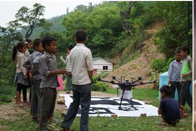
Local Children Gather to see the Medical Cargo Drone used in DrOTS Project at Pyuthan
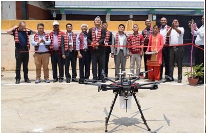
Inaugurating the DrOTS Project at Pyuthan 2019
Drones are also being used to identify and analyze mitigation measures in case of any serious event happens in the future. UAVs were used by the emergency service providers to monitor the health of the Toddbrook Reservoir walls in Derbyshire, the UK which later became unstable in 2019 and threatened to flood the nearby town. Since the detailed scanning was done earlier, the authorities were able to accurately identify and plan the appropriate mitigation measures in advance.
Likewise, authorities in different countries are also learning from each other's experience and best practices. In June 2020, The Governments of Kazakhstan and China attended a virtual session facilitated by UNICEF and shared best practices and exchanged experience in emergency management and disaster risk reduction systems. China has been using drones particularly focusing on pre-disaster prevention and integrated disaster mitigation efforts. Besides it is equally being used in post-disaster damage assessment and communication during disasters.
CHALLENGES
In spite of some progress, the applications of UAS in Nepal is largely limited to commercial purposes, and therefore its significance and acceptance in disaster risk management is yet not been fully realized and championed. Various agencies and non-profit organizations have undertaken initiatives to make the use of UAS in humanitarian aid and disaster context, however, due to several systematic and technical reasons that the use of UAS technology is yet not institutionalized in the DRRM sector in the country. The challenges of UAS technology and its use in DRRM in Nepal can be further categorized as follows:
● Lack of skilled manpower (data analysts, professionally certified pilots):
Despite the vital role of UAS in disaster assessments and in overall DRRM context, it is yet to be properly explored, formalized and scaled-up for country-wide application. The emergency responders, DRR volunteers still largely use conventional tools and techniques for DRRM activities. We lack DRRM professionals who are certified pilots and data analysts, and its absence hinders the robust and nationwide wholesome use of this technology.
● Drones use in emergency -Absence of standardization: Generic guidelines do exist, but we lack standard guidelines on the use of UAS during emergencies and standard operating procedures (SOPs) that would be very important for effective coordination among multiple responders and humanitarian agencies during a disaster situation.
● Lack of centralized digital system for UAS:
While there have been few positive changes in the recent UAS directives, few crucial mechanisms are yet to be included like; the digital registration process, provision for monitoring and surveillance of UAS flights and approvals of UAS pilot institutions, registration of drones without purchase documents (those purchased way back, or the ones donated by foreign institutions/individuals).
● Data privacy guidelines and concerns:Using UAS nowadays is much easier, but it's unregulated use without considering the privacy of the people and other data privacy concerns could lead to new tensions and disputes in the middle of a crisis. We still lack a disciplined and regulated approach towards humanitarian responses using UAS.To overcome this problem,the relevant agencies should come up with a national UAS code of conduct that includes data capture, data protection, data sharing and community engagement guidelines.
● Drone Pilot licensing policies and dedicated course: There are no institutions providing UAS pilot certification in Nepal. Also, there is no clear policy and guidelines regarding the licensing. This has negatively impacted the market standard, in terms of quality of drone services. In addition, the situation is also making the process tedious for any professional to use UAS more frequently i.e., as and when required. This limitation can be managed by focusing on preparing proper guidelines around pilot licensing standards and a suited course.
● UAV insurance: When we talk about insuring a drone, only 3rd party insurance is available as it is extremely challenging and difficult to ensure the whole UAS hardware. Particularly, due to the absence of insurance providers with proper UAS guidelines. Appropriate insurance policy adoption by the insurance companies is thus needed.
● Hardware issues: Most of the drones used in Nepal are imported. While only a few UAV repairing shops are available and that too are only capable of doing minor repairs and replacements. In this situation, it is very challenging and costly to get the UAS repaired in case of any serious damages.
● High cost of sensors (to capture large and dense vegetation cover :) Most common and affordable UAVs in the market rely on RGB cameras/sensors, while they are unable to provide quality data over the areas with dense vegetation cover. In Nepal, majority of areas are covered with vegetation, and the alternative lidar-based UAV technology to be used in such cases is highly expensive, hence making it non-economical in Nepalese market.
WAY FORWARD
● Nepal has significantly progressed and has figured out an increase in the applications of drones in multiple sectors. The number of drones registered in the country in the last decade has already surpluses the total number aircrafts registered in the country in the last 5 decades. Hence it is high time for drafting appropriate UAS regulations and policies and necessary capacity should be built on to meet the increasing demand and flow in the airspace.
● The Ministry of Home Affairs, the Civil Aviation Authority of Nepal and the Ministry of Communication and Information Technology are the key agencies who review drone permission requests based on different types of UAS. Although a digital system exists for different purposes, a centralized system to facilitate the UAS registration process, UAS flight permissions and its monitoring of the flights is urgently required. Similarly, the centralized integrated system should keep in track the entire drone missions that are being carried out throughout the country alongside the inventory of the drones and drone pilots.
● UAS is a very useful technology but at the same time very sensitive too. There has seen a significant increase in the use of drones for photography purposes. The UAS being a cutting-edge tool for rapid deployment during disaster, authorities providing permissions need to develop an effective and smooth process for the UAS coordination during disaster emergencies. Besides, a few drone operations have been reported that have not been complying with the standard operating procedures. Such kinds of flights should be discouraged and taken into strict regulations.
● Nepal Flying Labs, the first-ever flying lab co-created after the Gorkha earthquake 2015, has done several pilot humanitarian projects in the field of humanitarian action, medical health and DRRM coordination, for which they have been globally awarded several times. Likewise, amidst the Covid lockdown, the Robotics Association of Nepal prepared a national level UAS operators(pilots) database. Kathmandu University has been leading several UAS college projects and research works. Furthermore, ICIMOD has pioneered UAS for glaciological research. Similarly, several other private as well as non-government agencies have been using UAS and its products for accurate mapping disaster communications, and some risks, hazard modeling works. To benefit from this multiple users, the concerned government authorities need to organize a multistakeholder interaction and prepare a drone task force which could be mobilized all across the country during emergency situations and when needed.
● Nepal has a good potential to be a leading example regarding the use of UAS in DRRM as the country’s topography is challenging with the multitude of disasters. Nepal is country which released the UAS guideline very early in 2015 and over time, it has been amended to ensure smooth, ethical and contemporary applications in Nepal. Likewise, the Civil Aviation Authority of Nepal at the moment is working on new regulations as per the ICAO model regulations. Furthermore, they are developing a digital system to facilitate the UAS registration, hence the future for UAS in Nepal looks good and promising. Besides, a government led effective and coordinated approach recognizing and involving all key stakeholders for preparing necessary strategy, guidelines, manuals and SOPS could be a good move towards operationalizing the scientific use of UAS in Nepal.
