Use of Open Space (OS) came into practice from the 19th century in the United Kingdom and the United States in order to use as playing grounds, seating places and also helping residents and visitors get out to become active. Open spaces also maintain the aesthetic values of the ambient and help to maintain the beauty and environmental standards of the sites.
Different kinds of literature define open spaces from different perspectives, while in general, it is categorized on the basis of accessibility, ownership and use. The open spaces can be broadly categorized as i) External Public Space – all spaces between the private landholdings including public squares, streets, highways, parks, parking lots, stretches of coastline, forests, lakes and rivers, etc., ii)Internal Public Space –public institutions and public transport facilities and iii) External and Internal Quasi Public Space –privately owned public spaces such as sports grounds, restaurants, cinemas and shopping malls and others. Different cases from around the world, including this paper from Nepal, considered Spacesas a temporary home to thousands of people who need to quickly adapt to the new environment (in case of any disaster) for days, months, or even years.
Few good practical examples and anecdotes of the 1906 San Francisco earthquake showed us the relationships between the affected people of the city and open spaces when the 7.9 Richter scale earthquake strokes and subsequently fire in the tome. The study investigated the uses and the development of the open spaces during those times as they transformed open spaces into homes for the thousands of survivors. Similarly, Gujarat/Indiaearthquake showed many uses and roles of the open spaces during 2001, when many school children were in the open grounds for the flag hoisting. Because of their presence in open spaces, the causality was significantly lower compared to, if they would have been indoors. During the earthquake, the most important observation was that people were scared to go back to their houses and preferred to sleep in the open spaces.
We Nepalese people too experienced similar stories of open spaces as of San Francisco and Gujarat earthquake during and after the Gorkha earthquake in 2015. We observed that the affected people stayed outdoors in temple squares, open pockets of lands and fields in fear of aftershocks. Through the aerial survey, it was noted that most of the survivors had gathered in open areas and fields in the fear of another earthquake. It was interesting to record that the earthquake that came in duet within the span of two weeks, followed by unlimited aftershocks, virtually forced every household to look for an open space for temporary shelter. However, as a first response, the humanitarian agencies were able to set up tents in large community open spaces. After this mega-disaster, Nepal felt the practical needs of open spaces and started working in line with United Nations International Strategy for Disaster Reduction (UNISDR) recommendations. The latter states that the strategic planning and design of spatial elements and their influence on the natural and built environment are the directives of a city's capacity to absorb and recover from the effect of disasters.
InitiativesUndertaken
The Ministry of Home Affairs (MoHA) in coordination with UN-OCHA and a group of other international organizations officially launched the Nepal Risk Reduction Consortium (NRRC) to promote the UNISDR recommendations in 2011. Among others, Flagship#2 of NRRC had prioritized its works and identified 83 open spaces to secure emergency response within Kathmandu Valley and also to serve as hubs for responding to any large-scale disaster. It was a commendable effort to build an an‘in-house’ capacity of the Government to prepare, coordinate, and ensure timely response to any significant disaster. Under this flagship, the identification, allocation and planning of open spaces had received utmost priority. The “Open spaces” refer to the areas in Kathmandu that can be used for humanitarian response (camps for displaced persons, logistics and distribution centers, warehouse, security and incoming military coordination sites, etc.).The 83 identified open spaces are now also reflected in the Gazette book of GoN. Besides, few of them are already operationalized and put on standby mode.
Identification and Mapping of Open Spaces outside Kathmandu Valley
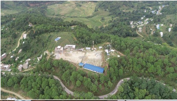
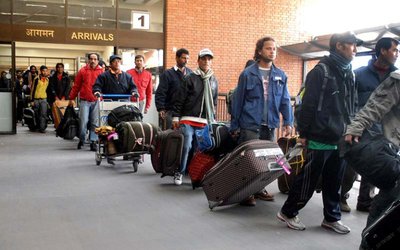
(Photo Credit: IOM)
Apart from emergency management and recovery, public open spaces can also be used to mitigate the disaster risk. The flood mitigation strategies in Nepal, first identify the flood-prone areas and to protect these areas from unauthorized encroachments and future development, authorities propose to allocate these spaces for open space uses. Conversely, Nepal National Policy for Disaster Risk Reduction -2018 adopted a policy to identify, develop and manage open spaces as an element to mitigate future risks.
Open spaces are primarily built for effective emergency response. However, the uses and importance of such spaces in towns and cities have been recognized at different levels. The areas of Open Spaces were more precisely can be used for ‘multi-purpose’, which reveals that the usage should not be limited to open spaces only during disaster response. The relevancy and appropriateness of this concept are already proven, when in many municipalities, such open spaces are also used for local Hat Bazzar, playing and picnic grounds, place for shows and exhibitions, and also frequently used in responding to COVID-19 in recent years. Besides, this concept also ensures a healthy built environment, controls pollution, promotes a clean environment and provides fresh oxygen, and also adds aesthetic value to the city. A small fee can be charged for use of the open spaces for different purposes and hence raise some funds to support regular maintenance of this facility in the benefit of local citizens. It is always helpful to develop locally tailored Standard Operating Procedures (SOPs) to guarantee the scientific operationalization of this facility in the long run.
Over the period of time, International Organization for Migration (IOM) Nepal has expanded significantly both in terms of program areas and target populations and has been contributing to the government of Nepal’s efforts to manage migration more effectively through a wide range of program activities in Disaster Risk Reduction and Resilience. IOM has also been supporting the Government of Nepal with the identification, mapping and protection of open spaces to be used for humanitarian purposes since 2013. Following the Gorkha earthquake 2015 in Nepal, IOM implemented the project entitled “People to People Support for Building Community Resilience through Recovery and Reconstruction” (P2P) in severely affected eight municipalities of Nepal. IOM had sought to support the Government of Nepal’s efforts to strengthen their preparedness and disaster risk reduction. Among others, Open Space was one of the major thematic areas of the project.
The project was successful in showcasing the good use of science and technology while implementing different activities planned around the open spaces. The activities mainly included identification, mapping, operationalization and endorsement by government authorities, including publication of municipality level ‘open space’ booklet. In this process, the project smartly used technologies like; cloud sourcing, mobile app., GIS, and use of drones and thus provided a good exposure to changing paradigm of Disaster Risk Reduction and Management (DRRM) at the local level in Nepal. Further, as a result of the project initiation, the partner municipalities realized the importance of open spaces and therefore came forward to support the whole process of identification, communication and demarcation of the suitable place in their respective municipalities. More importantly, the municipalities had officially endorsed the identified open spaces and agreed to make further investments for bringing them to operational status. The decisions in this regard are expected to have a long-term impact on the prospect of improved preparedness in the municipalities. As agreed by the municipal authorities, this move will allow them to establish multiple open spaces and thus ease the process of life-saving support and emergency response.
IOM in consultation with the Ministry of Home Affairs (MOHA), Ministry of Urban Development (MoUD), and Ministry of Federal Affairs and General Administration (MoFAGA) and with the concerned project municipalities, had developed and applied six primary criteria in the selection of open spaces and they are like accessibility, security, access to resources &water, land availability &topography, environmental concerns, and size.
Following these criteria, IOM updated the survey of 83 Open Spaces in Kathmandu Valley, including identification and mapping of open spaces in Bhimeshwor, Chautara, Sangachowkgadhi, Gosainkunda, Neelakantha and Gorkha municipalities of Nepal. On top of that, all these open spaces are now also integrated into the Building Information Platform Against Disaster (BIPAD) portal, which displays the information on all open spaces identified and verified by IOM in coordination with local and federal governments. This integration will further enable users to know their open spaces, distance from their locality and also the best way to get there in case of any disaster.
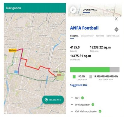
The open space mobile application called, Open Space Nepal, has been developed with the purpose of providing guidance for the public in the event of any disaster. Open Space Nepal is user-friendly, provides information in both English and Nepali, and information can be downloaded for offline usage on the mobile application to ensure maximum usability. An Example of an Open Space Mobile Application showing how routes are displayed (left), and how open spaces are displayed (right)is illustrated below.
All these identified open spaces are formally endorsed by the local municipalities, which bar any type of encroachment in the marked open spaces in the future. Besides this, few municipalities have already invested in operationalizing the open spaces to put them ready and standby for any future disaster. In coordination with the Department of Urban Development and Building Construction, MoHA, and MOFAGA, the IOM P2P project also promoted identified open spaces and disaster preparedness through outreach campaigns to increase awareness and preparedness levels in municipalities at-risk. In addition, the support also extended towards building warehouse capacity and stockpiling of essential items. The government is mulling to identify open spaces in other densely populated cities outside Kathmandu Valley.
Conclusion
It is not difficult to say that there is a significant potential to use public open spaces for strengthening preparedness and building disaster resilience in town. However, in order to harness this potential, these public open spaces need to be planned and designed as an interconnected system to boost the process of holistic approach to resilience building.
In summary, some of the important interventions that should be incorporated while using public open spaces for building disaster-resilient cities are as follows.
Ø Create a network of public open spaces contributing both to urban and disaster resilience.
Ø Different types of public open spaces contributing to different functions with appropriate capacity, location and connectivity.
Ø The public open spaces should not only be planned and designed for disaster resilience, but we should also connect them with the day-to-day life of the city, to function well during both emergency and non-emergency situations.
Ø The designated open spaces must be connected with basic facilities like; drinking water, sanitation and hygiene, electricity and also safety and security of the area.
Ø The open spaces must be accessible to all groups of populations, including elders, PWDs, women and children. Possible evacuation routes should be appropriately defined and shared between the local communities and other relevant authorities, to facilitate the easy reach of local populations.
Ø Well-tailored SOP is must to ensure scientific and appropriate operationalization of open spaces as per the local demands.
Dr. Karna is a well-trained Urban Governance and Disaster Risk Reduction Specialist, presently working as a freelance consultant for UN and other international agencies both in Nepal and abroad. He can be reached at sumankarna@hotmail.com.
Mr. Bimal Khatiwada possess 25 years of experiences in various capacity from research work to Project Management with having extensive works in disaster risk reduction sector. His most recent engagement was working with UNDP as a Disaster Risk Reduction Expert. Currently Mr. Khatiwada is working with Oxfam in Nepal as a Technical Coordinator-DRR & Resilience. He can be reached via: vimalkhatiwada@gmail.com