Scientists at the International Centre for Integrated Mountain Development (ICIMOD) have been mapping, and monitoring glacial lakes and glacial origin hazards since 1985 – when Dig Tsho lake in Khumbu, Nepal, knocked out a micro-hydro and caused nearly $3M of economic damages. The centre conducted the post-event assessment to this event and has now also conducted multiple major hazard assessments, including into disasters in Melamchi, Birendra Tal, Humla in Nepal and Chamoli, the South Lhonak disaster in Sikkim, India. Visit ICIMOD
Frequency:
Experts at the centre state that they are shocked at the increased frequency of glacial origin hazards –
In the 2000s experts would anticipate a glacial origin flood to hit the Hindu Kush Himalaya region once every 5 to 10 years.
In two months - May and June 2025 alone saw three glacial origin floods hit the region, in Nepal (Limi), in Afghanistan (Andorab valley) and Pakistan (Chitral, Hunza).
Monday saw not just one, but two glacial origin floods strike Nepal: in Rasuwa, and in Upper Mustang.
A three-fold increase in GLOF risk across HKH is projected by the end of the 21st century.
“The acceleration of these types of events is completely unprecedented in the HKH region. We need to delve deeper into the triggers that are resulting in cascading impacts,” states Saswata Sanyal, ICIMOD Disaster Risk Reduction Lead.
Size no longer a determinant of potential danger:
What’s also new, say experts, is the devastation that small lakes, some so small, or hidden, that we didn’t even know they existed, are now causing.
ICIMOD has mapped and assessed lakes’ danger for decades. Size has previously been one of the criteria for analysis of potential danger, with only those greater than 0.02 km2 considered, and priority given to potential downstream impacts and moraine-dammed glacial lakes, since these are considered particularly unstable.
On this criteria, Nepal has 21 potentially dangerous lakes, 25 are in Tibet Autonomous Region of China, and 1 in India (ICIMOD 2020).
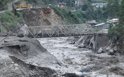
However, recent GLOF events have occurred by draining of newly formed (Supraglacial) ice dammed glacial lakes: this includes Monday's flood in Bhotekoshi Nadi in Rasuwa, and the rock avalanche in the bedrock dammed glacial lake and sequential breach of moraine dammed glacial lake in Thame, Everest region last year.
Researchers say it’s crucial that : mapping and monitoring efforts increase
Potentially Dangerous Glacial Lakes inventories be more frequently updated smaller, short-lived ice dammed lakes be analysed, the dynamics of glacier retreat and lake formation be incorporated for more dynamic and accurate hazard assessment
What is a supraglacial lake?
Supraglacial lakes form on the surface of glaciers, particularly in debris-covered areas. They are highly dynamic and ephemeral, often beginning as small meltwater ponds that gradually expand and sometimes merge to form larger supraglacial lakes. The detection of these lakes largely depends on the spatial resolution of satellite imagery. Freely available satellite data, such as from Landsat and Sentinel-2, have limited resolution and can typically only identify lakes above a certain size threshold, potentially missing smaller or short-lived water bodies.
Early satellite pictures and analysis show that the lake that drained yesterday was a small pond in December 2024 and its size significantly grew in the month of June 2025.
Temperature’s role in rising glacial origin events
Temperature rise is known to play a key role in the increasing frequency glacial origin floods, in two key ways:
First the formation and gradual expansion of glacial lakes – a longer-term process driven by sustained warming.
Second, short-term temperature extremes on individual days can act as triggers for sudden events such as ice avalanches, ice calving, or slope failures related to permafrost thaw.
Floods carrying heavily debris-laden water, known as non-Newtonian flow, have significantly greater impacts than floods involving water alone. In recent events, such flows have become more common, with floods increasingly mixed with large volumes of sediment and debris, causing severe damage downstream.
Several factors may be contributing to this trend. One is the thawing of permafrost (previously frozen ground) which destabilizes the surface and makes it more susceptible to erosion by floodwaters. Another is the shift in precipitation patterns in periglacial areas where more rainfall (instead of snowfall) leads to increased runoff and excessive erosion. These changes are closely linked to climate change, particularly rising temperatures, which are altering both the quantity and the nature of what flows downstream.
‘These events are signals and symptoms of really rising temperatures, and are more destructive than normal flood due to the debris and steep topography’ states Sharad Prashad Joshi, cryosphere monitoring specialist at ICIMOD.
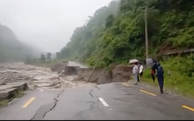
Extent of damage:
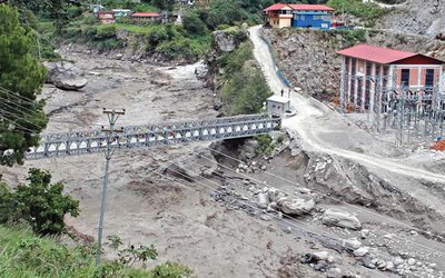
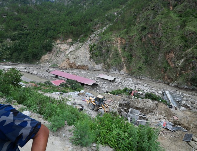
China - Nepal – 19 people missing 7 fatalities. 30MW of hydropower, 1 bridge, more than 100 EVs and blockage trade with China
How can we make communities safe?
Major investments are being made in disaster management in the region: ADB has started its BAR-HKH initiative in Nepal and Bhutan, which has a specific focus on mountain hazards
GCF just approved $36.1M for UNDP to lower four large glacial lakes in Nepal that ICIMOD had identified as of risk in its Potentially Dangerous Glacial Lake report: Thulagi, Lower Barun, Lumding Tsho, Hongu-2.
However apart from two lakes – Imja and Tsho Rolpa – we do not yet have the early warning systems or monitoring smaller sized lakes.
“We’re talking about a huge expanse of terrain where these sorts of lakes can develop, and the monitoring data and method to keep on top of pace of changes we’re now seeing simply does not yet exist,” says Qianggong Zhang, head of Climate and Environmental Risks at ICIMOD.
Resources
ICIMOD’s GLOF dashboard, compiles information on all recorded instances of glacial lake outburst floods (GLOFs) of High Mountain Asia starting from the 1830s. Aside from information on fatalities and injuries, the dashboard allows users to filter the GLOFs by country, river basin and lake type.
About International Centre for Integrated Mountain Development (ICIMOD)
The Hindu Kush Himalaya (HKH) region stretches 3,500km across Asia, spanning eight countries – Afghanistan, Bangladesh, Bhutan, China, India, Myanmar, Nepal, and Pakistan. Encompassing high-altitude mountain ranges, mid-hills, and plains, the zone is vital for the food, water, and energy security of up to two billion people and is a habitat for countless irreplaceable species. It is also acutely fragile, and vulnerable to the impacts of the triple planetary crisis of climate change, pollution, and biodiversity loss.
The International Centre for Integrated Mountain Development (ICIMOD), based in Kathmandu, Nepal, is an international organisation established in 1983, that is working to make this critical region greener, more inclusive and climate resilient. For more information, read our Strategy 2030 and explore our website.
Our reporter writes, Not only has the rate of snow melting in the Nepali mountains increased due to rising temperatures, but the increase in temperatures has also started causing rainfall in the mountains. He claimed that the rainfall has further increased the rate of snow melting, leading to the formation of many glacial lakes.
There are more than 47 glacial lakes on the border of Nepal and Tibet. This does not include newly formed glacial lakes. There are also many glacial lakes growing on the highest peaks.
He points out the need for a new study to determine the status of the glaciers after 2015. The first network should be established at the government level in both countries to create an early warning system network.
Then, regional organizations such as SAARC and BIMSTEC should be able to build and operate an information exchange network through an early warning system.Apart from this, organizations involved in study and research can also share information through partnerships, which has been seen only rarely since the Tibet Lake explosion.
China has a strong institutional and technical infrastructure from which reliable information can be obtained. He added, "We do not have our own satellites, nor do we have super-technological computers, so it is necessary for the government to take a partnership initiative with the Chinese government."'Rasuwa's devastating flood caused by supraglacier outburst'
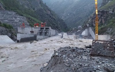
The Department of Hydrology and Meteorology (DHM) has reached a preliminary conclusion that Tuesday’s devastating flood from the Lhende Stream in Rasuwa was caused by a supraglacial lake outburst in China.
According to satellite data, the flood was likely triggered by the bursting of a supraglacial lake (a lake formed on top of a glacier), located about 36 kilometers north from the Nepal-China border at Rasuwagadhi (latitude 28.4043, longitude 85.6469), at an altitude of around 5,150 meters.
Before the incident, the lake covered approximately 0.74 square kilometers. After the flood, its area was found to have decreased to around 0.60 square kilometers. This change in size indicates a significant release of water, supporting the conclusion that a lake outburst caused the flood in the Lhende Stream.
Flood expert Binod Parajuli from the Department stated that further information is expected from China and upcoming satellite images will help clarify the details of the incident. The Department will continue its study of the event.
The International Centre for Integrated Mountain Development (ICIMOD) has earlier also suggested that the flood was caused by the outburst of the glacier lake
- Global IME Bank Receives Best Bank Award 2025
- Jul 11, 2025
- Weather Forecast: Partly To Generally Cloudy Across The Country With Light Rain Fall At One Or Two Places In Koshi, Gandaki, Bagmati, Lumbini And Sudurpaschim Provinces
- Jul 11, 2025
- REEEP-GREEN's technical support is invaluable in the process of preparing the MEP: Mayor Bimala Rai
- Jul 10, 2025
- Birendra Raj Pandey Elected President of the Confederation of Nepalese Industries (CNI)
- Jul 10, 2025
- Ujyalo Foundation organized the One-Day Feminist Conference (OFC) 2025
- Jul 10, 2025