Kosi Could Abandon its Course For Ever
We might be very close to the days when the swollen Kosi would permanently abandon its present course and it would be freely roaming over its vast eastern floodplain. The damages, that resulted from the 2008 bursting of the eastern embankment, would pale in comparison with the great losses of life and property consequent upon the coming catastrophic Kosi flooding. Even the distant West Bengal and Bangladesh lying on the old courses of the Kosi might not be completely out of the Kosi flood danger.
Lesson from China’s Bitter Experience
We should draw lesson from the terrifying experience of catastrophes when the Yellow river of the China known as the Sorrow of China just like the way the Kosi is known as the Sorrow of Bihar used to burst periodically its embankments in course of high floods. The Yellow river like Kosi now flowing well above the surrounding lands burst its embankments in 1931 and 1887 that resulted in loss of life between 2 to 4 million and 1 to 2 millions respectively.
River Bed Rise
Kosi rising in the Himalayas and emptying into the plain at Chatra after traversing the mountain region, brings with her every year an enormous quantity of sediments estimated at 120 million cubic meters along with 52 billion cubic meters of water. The annual volume of Kosi sediment is about 5 times greater than that of the Sutlej at Bhakra, and two times greater than that of the Nile at Aswan.
Various studies done on Kosi so far come to one common conclusion - the Kosi carries enormous load of sediments that it is unable to transport far beyond. The river, therefore, deposits huge quantity of sediments. In this process of building up an inland delta, the river shifted over 120 km from east to west during the period from 1736 to 1954.
In 1966 a study of the delta cone of the Kosi river made by Prof Gole CV Dr. Chitale M. appeared in the ":Proceedings of the American Society of Civil Engineers". The study explains that the delta building of Kosi was still incomplete. The authors have cautioned that the existing measures (embankments) may be short lived.
The studies carried out by Sanyal (1980) and Gohain & Prakash show that in the period between 1963 and 1974 there was high aggradations upstream of the barrage. The area just downstream of the barrage had been marked by a small degradation. But further downstream, there had also been increased aggradations.
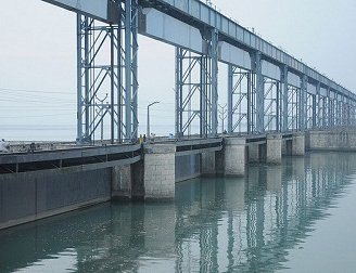
Alarming Reduction in Kosi Barrage Capacity
The Kosi barrage had been designed for a maximum flood discharge of 9.5 lakh cusecs. The maximum flood water level was 25 feet above the bed level. Similarly, the normal pond level was 15 feet above the bed level. According to Gohain & Prakash the annual rate of the sedimentation upstream barrage based on observations as of the early 1980s is about 5 cm per annum. It implies that within the last 60 years after the commissioning of the barrage a layer of 3 meters thick sediments might have already deposited on the river bed. Now the maximum flood water depth might be only 60% of the original depth.
We can calculate the present maximum flood discharge capacity of the Kosi barrage assuming that the maximum water depth would be only 60% of the original depth. It can be roughly calculated based on the formulas of French Engineer Antoine Chezi and Irrish Engineer Robert Manning. We will find that at present the barrage might be able to safely discharge a flow only up to 5.0 lakh cusecs. Gohain & Prakash have reported in early 1980s “If the discharge exceeds 8400 cumecs ( or 3 lakh cusecs), which is fairly common, the whole area between the two embankments is submerged.”
Sedimentation Problems Will Worsen
Within the last 60 years twice the flood discharges up to 9 lakh cusecs had been recorded. But after 1968 the maximum Kosi discharge never crossed the 6 lakh cusecs limit. It is now an accepted scientific conclusion that the high flood discharges resulting from heavy rainfalls are the primary cause of increased sediment flow. The following is an excerpt from the Karnali project report prepared under the World Bank’s assistance.
“The sediment load from mountainous areas, such as the Himalayas and the Karakoram, is believed to be derived extensively from localized mass wasting (landslides ) rather than from generalized surface erosion (Carson 1985). Sediment yield should thus be better correlated to precipitation or runoff events which are two of the main factors causing landslides and gully erosion.”
It is seen that within the last 45 years the Kosi flood discharges were far below the maximum discharges already recorded twice within the last 60 years. As a result, we might not be wrong to conclude that within the last 45 years the Kosi barrage project might have been spared to face serious sedimentation problems. However, there is a great probability that in very near future the situation could take an alarming turn.
What Comes Next?
In 2008 the Kosi had burst the eastern embankment and shifted its course heading to south- east when the flood discharge was only about one lack and sixty thousand cusecs. This flood discharge is quite insignificant compared to about 9 lakh cusecs. flood discharges, which have already been recorded twice within the last sixty years. Despite the fact that the Kosi has changed its course at such a low flood discharge, Bihar suffered very heavy losses. It is frightening even to think of the horrors if the Kosi would suddenly burst the embankment at a time when the flood discharge is close to nine lack cusecs. There would be a total devastation of almost the whole north-east Bihar and a large area of Nepal’s Sunsari district if we failed to take in time adequate preventive measures.

Dr. A.B. Thapa
Thapa writes on water resources issue
- Dudhkosi Multipurpose Project
- Jul 11, 2022
- Dudh-Kosi Power Project And Kosi Treaty
- Sep 27, 2021
- Uttarakhand Glaciers And Recent Disaster: A Lesson To Our Country
- Mar 02, 2021
- Multipurpose Langtang After Melamchi: Inter-Basin Water Transfer
- Nov 04, 2020
- Large Storage Dams Projects Wary of Giving Away Children’s Inheritance
- Dec 22, 2019