Complete disruption to navigation on the Gandak River is anticipated in the wake of the operation at full capacity of the Gandak Irrigation Project, which has been implemented according to the Gandak River Treaty, 1959 signed between Nepal and India allocating almost the entire non monsoon season flow for irrigation.
The Gandak River was navigable by country crafts from the time immemorial. The river had provided principle means of communication in the area traversed by it. The Joint Steamer Company providing navigation services on the Ganges had even conducted survey during the last years of the British rule with the view to extend their services on the Gandak River.
At one point even the provincial government of Bihar had considered making one of the two Gandak main irrigation canals navigable as an alternative to the river course navigation . Obviously, this is now the only recourse to save the Gandak navigation unless both countries agree to take drastic measure to do away with the Gandak Treaty.
Physical Features
The River Gandak after passing through the Deoghat flows in a succession of rapids and pools until it reaches Tribeni. Passing Tribeni, the river traverses a distance of about 310 kms before it empties into the Ganges at Hajipur, opposite Patna.
The Gandak River becomes much wider after debouching into the plains at Tribeni, where it acquires the characteristics of a deltaic river. Except for four rapids at Damran, Narasahi, Thari and Patlahwa between Tribeni and Bagaha where there are boulders and shingles the bed of the river in most of its course down Tribeni is sandy.
Pre-Gandak Project Status
The Gandak River had always been navigable throughout the years by country boats from the confluence with the Ganges up to the Tribeni in Nepal. It was a very important channel of trade of this area even in the early days of the British rule and the transport on this river can be traced back to 1700 AD.
From the view point of navigation the Gandak waterway can be divided into the following four sections. Deoghat-Tribeni Section (78 km), Tribeni-Bagaha Section (50 km), Bagha-Mallahi Section, Mallahi-Confluence.
A study conducted by the NCAER (National Council of Applied Economic Research) in 1963 indicates that the total annual traffic at that time at Tribeni and upstream from Tribeni was about 20,000 tons. This reach is navigable for about eight months in a year. Boats of only two tons capacity ply in this area.
The volume of the traffic on Tribeni-Bagaha sector, excluding the appreciable quantities of boulders and shingles picked up from the river bed, according to NCAER study aggregates to about 20,000 tons. Boats up to 15 tons capacity play in this section.
Country crafts up to 20 tons capacity used to ply on Bagaha-Mallahi section.
The volume of traffic on Mallahi-Confluence Section according to NCAER study was about 40,000 tons. Country crafts with capacity of 20 tons or more used to ply. All the boats up and down the river had to stop for some time near the railway bridge at Hajipur for lowering and raising their masts and sails.
Joint Steamer Companies' Surveys
Until the advent of the railways and road transport, the Gandak supplied the principal means of communication in the area traversed by it. In spite of the introduction of alternative mode of surface transportation, a sizeable traffic continued to exist on the Gandak River. So the Government of India had shown in past considerable interest in developing Gandak waterway for navigation.
The Joint Steamer Companies operating on the Ganges were providing services for very long time before the complete closure of such services in 1950s. They were operating feeder services on the lower reaches of the Karnali River (known as Gogra in India) also. However, there was no feeder service on the Gandak to link with the Joint Steamer Navigation Services on the Ganges. They had carried out surveys on the Gandak River during 1935, 1941 and 1946 with a view to extend their services on the Gandak upto Sohansi Ghat and their conclusions were:
In 1935 Survey: So far as the Gandak River is concerned a service can be inaugurated with probable modification in running periods depending on seasonal conditions for bridge headways at Hajipur according to type of vessels used.
In 1941 Survey: Seen during the half flood period, the Gandak appeared navigable though the key shoals at Anche, Sattar Ghat would require careful watching and bandalling.
In 1946 Survey: Gandak is as easy to navigate during the dry season as the Ganga and the Gogra above Patna, where the depths of three feet are frequently registered in various shoals which are kept navigable by bandalling.
The Govt. of India's Survey
The Government of India also had carried out the hydrographic surveys of the Gandak River to investigate the possibilities of developing inland water transport. The Central Water and Power Commission had done the survey works. The study covered the stretch of the Gandak River between Bagaha and its confluence at the Ganges.
In April 1950 Survey: This low water survey recorded 40 shoals below 3 feet.
In December 1957 Survey: During this mid-water survey the condition of the river was found to be comparatively better. In this survey only 3 shoals under 3 feet, 3 shoals between 3-4 feet and 13 shoals between 4-5 feet were recorded. During this survey a shoal of 2 feet was recorded at the mouth of the river at the Ganges. This shoal is created by shallow depth due to sand deposit.
However, nothing came out of those surveys. The service on the Gandak had always been by country crafts, provided by a large number of boat-owners and boatmen from Patna without any coordination with the Joint Steamer Company's services.
The UNDP Supported Nepalese Study (1967)
The main objective of the study was to find out the possibility of developing water transport from the nearest port to terminal points inside Nepal. All three major rivers the Karnali, the Gandak and the Kosi were investigated. The study team recommended to give priority to the Gandak River for early development because at that time the Gandak River had sufficient water for developing water transportation and the location of this river was favourable for effectively serving the whole country.
Impediments to Navigation
There are several engineering works on the Gandak River at present. Some of them were there since a long time. They are old and new railway bridges with low clearance above the high water level at Hajipur. They are serious impediment to navigation development on the Gandak River. But of all such impediments, the Gandak Project at Bhaisalotten is the most serious and it can preclude the possibility of developing in future navigation on the Gandak.
An agreement between HMG Nepal and the Govt. of India on Gandak Project was signed on December 4, 1959. This agreement has been amended and the revised agreement was signed on April 30, 1964. The Gandak Project comprises of a barrage and the canals for irrigation and power generation.
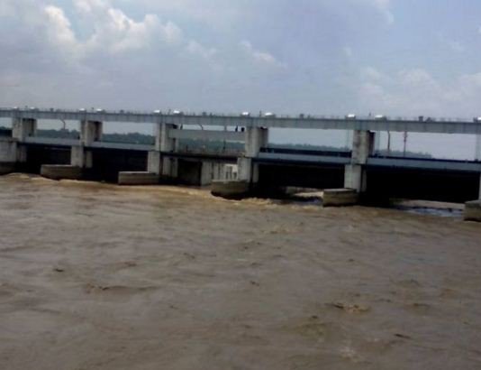
Gandak Barrage and Canals
A 835 m long barrage has been built across the Gandak River at Bhaisaloten. About half the length of the barrage is in Nepal and the other half in Indian territory. The barrage blocks the waterway. The navigation was going to be blocked. But according to the Gandak Agreement the Government of India would have to provide locking arrangements for facilitating the riverine traffic across the barrage free from payment of any tolls. It was proposed by India to provide lock with a width of only 6.1 metres. The UNDP supported Nepal's study had pointed out that the lock width should at least be 15.25 metres.
There are two main canals. They are main western canal and main eastern canal with head discharge of 15,000 cusecs and 14,140 cusecs respectively primarily for irrigation purposes. A very
large volume of water is needed to irrigate lands within the total command area of the Gandak Project. During the rainy season the water demand for irrigation will not be too heavy. The demand increases when the rains stop. Ultimately in dry season months the river would even become completely dry. In this context the question of continuity of navigation becomes a crucial issue. If this problem is not properly resolved then the navigation would not only become difficult but would be precluded for ever.
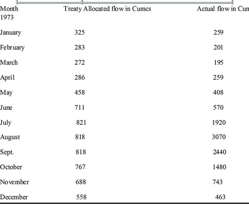
Treaty Allocated Flow for Irrigation
The monthly flows of the Gandak river allocated for irrigation by the Treaty and the actual river flow for the year 1963 is given below:
Bihar Government and Canal Navigation
The Gandak had always been a waterway of great importance for Bihar as well as Nepal. It was apprehended that this important waterway was going to be adversely affected by a barrage cum road to be built across this river near Bhaisalotan with canals on either side for irrigation. So immediately after the sanctioning of this project by the Govt. of India for the construction, the Bihar Government requested the National Council of Applied Economic Research, New Delhi to conduct a study on Gandak to determine the extent of river conservancy work that would be required for preserving the navigation potential of this river. Originally the proposed study included the economics of inland navigation on the Gandak vis-a-vis the Gandak canals. However, at a later date the National Council was informed to drop the inland navigation vis-a-vis the Gandak canals study.
Gandak Canal Navigation
The conversion of one of the two main Gandak canals into a irrigation cum navigation canal ( including power generation component if feasible) is the only recourse to save the Gandak navigation. The proposed modification could open a relatively deep waterway route for vessels on a par with the Patna-Faracca sector Ganges waterway, which would be conducive to great reduction in transportation cost. Thus this waterway would have helped to herald completely a new era of development by facilitating trade and industrialization in North-West Bihar, Eastern UP and Western Nepal.
Ref:
(1) Inland Waterways for Nepal: Dr. AB Thapa
Govt. of Nepal, 1967
(2) Traffic Survey of the Gandak River:
National Council of Applied Economic Research
New Delhi, January, 1964

Dr. A.B. Thapa
Thapa writes on water resources issue
- Dudhkosi Multipurpose Project
- Jul 11, 2022
- Dudh-Kosi Power Project And Kosi Treaty
- Sep 27, 2021
- Uttarakhand Glaciers And Recent Disaster: A Lesson To Our Country
- Mar 02, 2021
- Multipurpose Langtang After Melamchi: Inter-Basin Water Transfer
- Nov 04, 2020
- Large Storage Dams Projects Wary of Giving Away Children’s Inheritance
- Dec 22, 2019