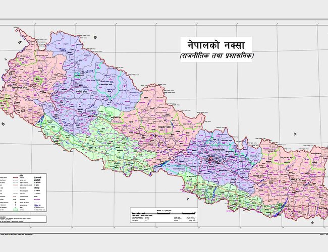
Nepal Government made public the updated political and administrative map of the country by incorporating Kalapani, Lipulek and Limpiyadhura in it on Wednesday.
Despite clear rights of possession from the historical evidence, these parts of the country were erroneously left in the existing map of the country for years.
Launching the updated map of the country amidst a function in Singha Durbar, Minister for Land Management, Cooperatives and Poverty Alleviation Padma Kumari Aryal said that it was a historical and memorable moment for all Nepalis to launch the updated map of the country by including left out parts of the country again in the map.
She said that the government had updated its political and administrative map on the basis of the historical Sugauli Treaty signed between Nepal and the then East India Company on March 4, 1816.
“Though the Treaty has clearly mentioned that all the territory which is east of the Kali River belongs to Nepal, some parts, including Gunji, Nabi, Kuti, and Limpiyadhura lying east of the Kali River were left out in the existing map,” Aryal said.
She said that the map was issued as per the feelings of patriotic Nepali people to keep the country’s sovereignty and territory intact.
“The act of issuing the updated map of the country including country’s entire territory had not only changed the map of the country in the global hemisphere but had also promoted the pride and self- confidence of Nepali people,” she said.
Stating that the country had passed through various ups and downs in last two-and-a-half centuries in the nation-building process, Minister Aryal said the present government led by KP Sharma Oli was determined to keep the heads of the countrymen high by respecting the historical contribution of their forefathers in protecting the country’s territory.2
After a green signal of the Ministry of Foreign Affairs on the updated map prepared by the technicians under the Ministry of Land Management, a Cabinet meeting held on Monday had approved the updated map of the country.
Minister Aryal said that all the testimonies of the government, as well as textbooks, would include the updated map of the country. She urged all agencies and firms to use the updated version of the map in their work and office.
Minister Aryal said that the government was expecting a positive response from the government of India to the issuance of the new updated map of the country.
She said that the government was ready to resolve any border issues through diplomatic channels and negotiations.
The updated map of the country includes all seven states, 77 districts, 753 local levels, and international border of the country. However, the ministry officials said they were working to measure the total area of Nepal as per the new map.
- India’s External Affairs Ministry’s Senior Officials Says Indo-Nepal relations are ever expanding
- Jul 05, 2025
- Bhutan Government Unveils Three Pronged Strategies To Tackle Skilled Migration Crisis
- Jul 05, 2025
- Weather Forecast: Generally Cloudy Across The Country With Heavy Rain At One Or Two Places Bagmati And Koshi Provinces
- Jul 05, 2025
- FNCCI President Dhakal Urges British Companies to Invest in Nepal
- Jul 04, 2025
- Nepal Is Expected To See 60,000 People Infected with Dengue This Year
- Jul 04, 2025