Not only has the rate of snow melting increased in the Xizang Autonomous Region of China, but also in Nepali mountains, leading to large-scale flash floods due to rising temperatures becoming almost commonplace nowadays. The temperature rise has begun to cause rainfall in the mountains and rapid snowmelt, posing a risk of glacier outbursts.
Experts suggest that the increased intensity of rainfall has accelerated the rate of snow melting, resulting in the formation of numerous lakes on the mountaintops larger than the glaciers. A report indicates that there are more than 47 glacial lakes on the Nepal-Xizang border, not including newly formed ones.
Experts emphasize the need for a new study to assess the status of glaciers post-2015. They recommend the establishment of a joint government-level network in both countries to develop an early warning system.
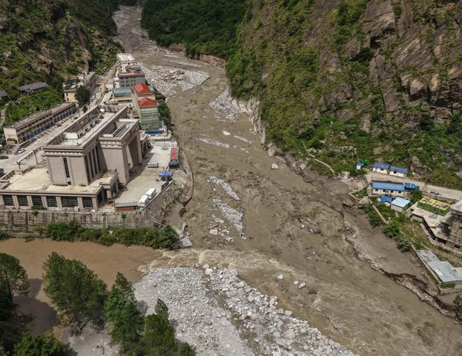
China has a robust institutional and technical infrastructure that provides access to reliable information. Experts emphasized the need for a partnership with the Chinese government due to the lack of satellites and advanced technology in Nepal. The devastating flood in Rasuwa was attributed to a supra-glacier outburst, as determined by the Department of Hydrology and Meteorology (DHM). Satellite data indicated that the flood resulted from the bursting of a supra-glacier lake located north of the Nepal-China border at Rasuwagadhi. The lake's size decreased significantly after the flood, confirming the outburst theory.
Flood expert Binod Parajuli stated that additional information from China and upcoming satellite images will help clarify the incident.
The International Centre for Integrated Mountain Development (ICIMOD) had also previously suggested that the flood was caused by a glacier lake outburst.
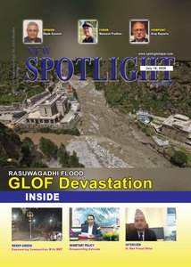
Hazards Experts Shocked By Growing Pace of Glacial Origin Floods
The China-Nepal flood was caused by the draining of a 'supraglacial' lake that began forming as a small pond at the end of December 2024 and grew significantly by June 2025. The International Centre for Integrated Mountain Development (ICIMOD) has been mapping and monitoring glacial lakes and glacial origin hazards since 1985, following the Dig Tsho Lake incident in Khumbu, Nepal, which caused damage to a micro-hydro facility and nearly $3 million in economic losses. The centre conducted a post-event assessment of this incident and has also carried out multiple major hazard assessments in various locations, including Melamchi, Birendra Tal, and Humla in Nepal, as well as Chamoli and the South Lhonak disaster in Sikkim, India.
Experts at the centre are alarmed by the increased frequency of glacial origin hazards. In the 2000s, experts would expect a glacial origin flood to occur in the Hindu Kush Himalaya region once every 5 to 10 years. However, in just two months, May and June 2025, three glacial origin floods hit the region in Nepal (Limi), Afghanistan (Andorab valley), and Pakistan (Chitral, Hunza). On
Monday, two glacial origin floods struck Nepal in Rasuwa and Upper Mustang. A three-fold increase in GLOF risk across the HKH region is projected by the end of the 21st century.
Saswata Sanyal, ICIMOD Disaster Risk Reduction Lead, emphasizes the unprecedented acceleration of these events in the HKH region and the need to investigate the triggers leading to cascading impacts.
Size no longer a determinant of potential danger:
Experts also point out that the destruction caused by small lakes, some of which are so tiny or hidden that we were previously unaware of their existence, is a new concern.
ICIMOD has been evaluating the danger posed by lakes for many years. Previously, the size of the lakes was a key factor in determining their potential threat, with only those larger than 0.02 km2 being considered. Priority was given to lakes with potential downstream impacts and moraine-dammed glacial lakes due to their perceived instability. According to ICIMOD's 2020 report, Nepal has 21 potentially hazardous lakes, Tibet Autonomous Region of China has 25, and India has 1. However, recent GLOF events have been linked to the drainage of newly formed supraglacial ice-dammed glacial lakes, such as the flood in Bhotekoshi Nadi in Rasuwa and the rock avalanche in the bedrock-dammed glacial lake leading to the breach of a moraine-dammed glacial lake in Thame, Everest region last year. It is recommended that inventories of potentially dangerous glacial lakes be updated more frequently, smaller short-lived ice-dammed lakes be analyzed, and the dynamics of glacier retreat and lake formation be considered for a more dynamic and accurate hazard assessment.
What is a supraglacial lake?
Supraglacial lakes develop on the surface of glaciers, especially in areas covered with debris. They are constantly changing and temporary, often starting as small pools of meltwater that gradually grow and sometimes combine to create larger supraglacial lakes. Detecting these lakes relies heavily on the resolution of satellite imagery. Available satellite data, like from Landsat and Sentinel-2, have limited resolution and can usually only spot lakes above a certain size threshold, potentially missing smaller or short-lived water bodies.
Early satellite images and analysis indicate that the lake that drained yesterday was a small pond in December 2024 and significantly expanded in June 2025.
The role of temperature in the increase of glacial-related events
Temperature increase is a significant factor in the rising occurrence of glacial-related floods, in two main ways:
Firstly, the formation and gradual growth of glacial lakes – a process influenced by prolonged warming.
Secondly, short-term temperature spikes on specific days can trigger sudden events like ice avalanches, ice calving, or slope failures linked to permafrost thaw.
Floods carrying water heavily laden with debris, known as non-Newtonian flow, have much greater impacts than floods involving just water. In recent incidents, such flows have become more frequent, with floods increasingly mixed with large amounts of sediment and debris, causing extensive damage downstream.
There are multiple factors contributing to this trend. One factor is the thawing of permafrost, which destabilizes the surface and increases susceptibility to erosion by floodwaters. Another factor is the changing precipitation patterns in periglacial areas, where increased rainfall, rather than snowfall, leads to more runoff and erosion. These changes are closely tied to climate change, particularly rising temperatures, which are altering the quantity and nature of downstream flows. According to Sharad Prashad Joshi, a cryosphere monitoring specialist at ICIMOD, these events are indicative of rising temperatures and are more destructive than typical floods due to debris and steep topography.
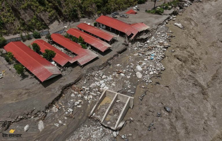
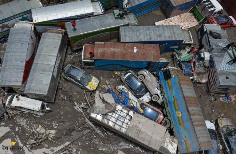
The extent of the damage includes 19 people missing and 7 fatalities in the China-Nepal region. Additionally, 30MW of hydropower, 1 bridge, over 100 EVs, and trade with China have been affected by the flooding.
How can we make communities safe?
GCF has approved $36.1M for UNDP to mitigate the risks posed by four large glacial lakes in Nepal identified in ICIMOD's Potentially Dangerous Glacial Lake report: Thulagi, Lower Barun, Lumding Tsho, and Hongu-2.
However, early warning systems and monitoring for smaller lakes are lacking, except for Imja and Tsho Rolpa. Qianggong Zhang, head of Climate and Environmental Risks at ICIMOD, highlights the challenges of monitoring the vast terrain where these lakes can form and the need for improved data and methods to track changes.
ICIMOD's GLOF dashboard provides information on recorded glacial lake outburst floods (GLOFs) in High Mountain Asia since the 1830s, including details on fatalities, injuries, and filtering options by country, river basin, and lake type.
The Hindu Kush Himalaya (HKH) region spans eight countries and is crucial for the food, water, and energy security of two billion people, as well as biodiversity. ICIMOD, based in Kathmandu, Nepal, aims to enhance the region's sustainability and resilience through its work. Explore ICIMOD's Strategy 2030 and website for more information.
NDRMA Says GLOF IS Behind Devastating Flood in Rasuwa
The frequency of floods triggered by Glacial Lake Outburst Flood (GLOF) in Nepal is on the rise, posing a significant risk to life and property.
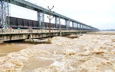
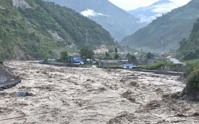
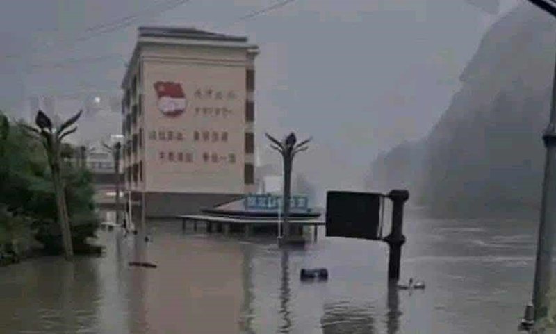
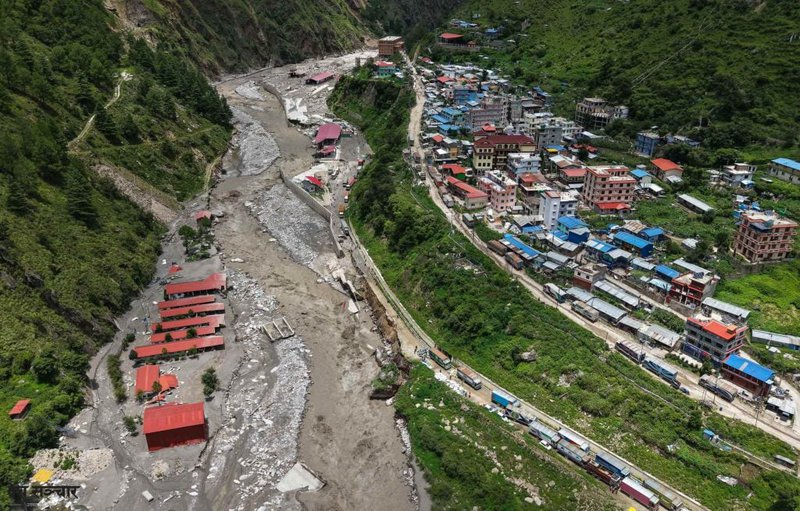
On Tuesday (8 July) morning, a major flood entered Nepal from the Himalayan region of Xizage, China, through the Nepal–China border. The flood was a result of a glacial lake located approximately 35 kilometers above Rasuwa, Nepal, bursting.
The melting snow had formed a large lake, which eventually led to the flood, as stated by Dinesh Raj Bhatt, Executive Chief of the National Disaster Risk Reduction and Management Authority (NDRMA). The glacial flood followed a path from Lhendekhola to Bhotekoshi and then Trishuli, affecting various areas in Nepal.
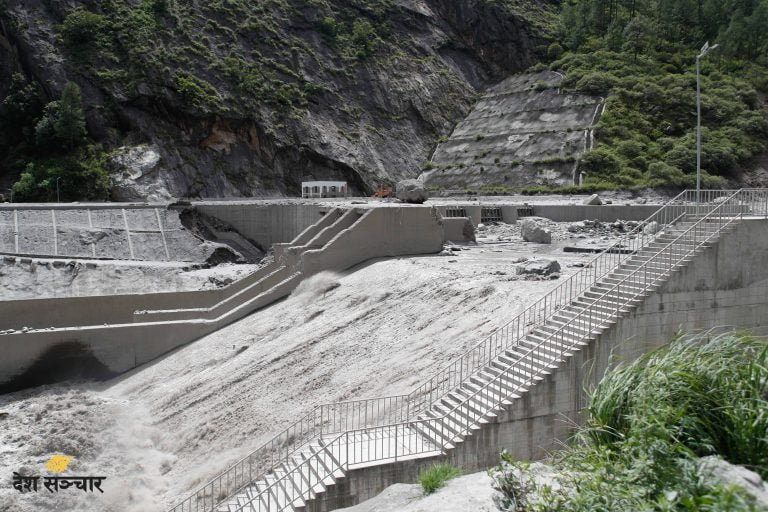
Satellite images from China and other sources confirmed the origin of the floodwaters from the glacial lake. The size of the glacial lake had significantly reduced from 638,000 square meters on Sunday to 435,000 square meters after the flood on Tuesday. The previous week, the lake had contained 525,000 square meters of water.
Bhatt noted that the floodwaters created a substantial depression as they entered Nepal, with some areas still showing remnants of water. He attributed the GLOF event to the impacts of climate change, which are accelerating the melting of snow. In Mustang’s Lomanthang, a recent flood is also suspected to have been caused by a glacial lake burst or leakage in the upper region, prompting a local team to investigate. Additionally, in the month of Jestha (May–June), two glacial lakes above Tilgaon in Humla burst, leading to floods.
In previous years, floods from glaciers in Nepal's high mountains have reached villages. Last year, in the final week of Shrawan (July–August), a glacial lake burst in Solukhumbu destroyed Thame village. In 2021 (2078 B.S.), a similar flood occurred in the upper Himalayan region above Melamchi. Bhatt emphasizes that due to the increasing number and bursting of glacial lakes in the Hindu Kush Himalayan region, dedicated studies are required.
Dr. Nitesh Khadka, a scientist at the Chinese Academy of Sciences, explained that the flood in Rasuwa was caused by water leaking from a supraglacial lake covered by snow and debris. Such supraglacial lakes, which form due to fluctuating temperatures in mountainous regions, are dynamic and temporary in nature.
Many of the lakes seen in Xizage today did not exist before 2021. Dr. Khadka stated that small lakes seen in 2022 had grown significantly by 2023, and one of those lakes, which had disappeared in December 2024, reappeared last Saturday.
Glaciologist Amrit Thapa mentioned that a large amount of snow melted a few days before the flood in Rasuwa. He explained that image analysis showed snow present on Friday had completely melted by Sunday. "This melted snow and ice chunks collected in a large pond formed on the glacier. The surrounding land was weak and couldn’t support the pressure, resulting in the flood," he elaborated.
The fact that water still remains in the large pond on the glacier’s surface supports his assessment. Thapa noted that as temperatures rise in the summer, snowmelt increases, and the concurrent rainfall further increases the risk of glacial lake outbursts in every Himalayan region.
Researcher Sudeep Thakuri pointed out that the increasing temperatures caused by climate change in Nepal's Hindu Kush Himalayan region are hastening the melting of snow. The International Centre for Integrated Mountain Development (ICIMOD) has also raised concerns about the growing number of glacial lake outbursts and leaks in Nepal, underscoring the importance of ongoing monitoring and research. Nepal has 21 high-risk glacial lakes, and there are 47 such lakes in border areas where drainage into Nepal poses a heightened risk. No comprehensive study on glacial lakes has been conducted since 2015.
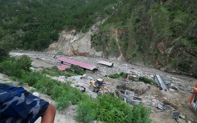
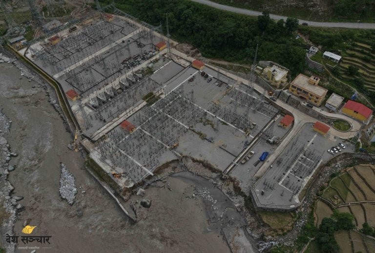
"Rasuwagadhi Hydropower, along with the 60-megawatt Trishuli-3A, the 21-megawatt Trishuli, and the 15-megawatt Benighat hydropower project, have all experienced damage," Maharjan stated. "The flood damage has led to a complete halt in the 200-megawatt generation since Tuesday," he added.
Rescue Operation
Despite the sudden and unprecedented flash flood, the rescue operation carried out by the Nepal Army, Nepal Armed Police, and Nepal Police was commendable. They successfully rescued dozens of people.
The Nepali Army utilized two helicopters to evacuate and rescue 55 individuals from flood-prone areas along the riverbanks to safer locations, as reported by Assistant CDO Adhikari. Additionally, a couple who had climbed a tree to escape the flooded Trishuli River in Nuwakot was also rescued.
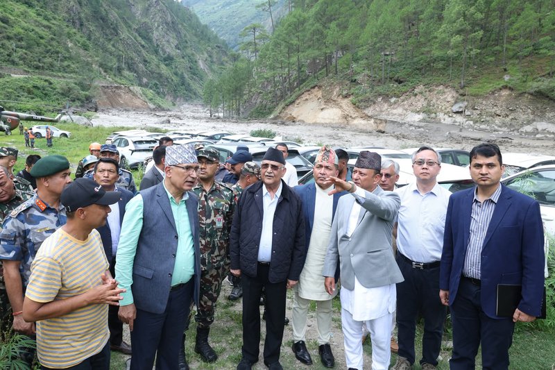
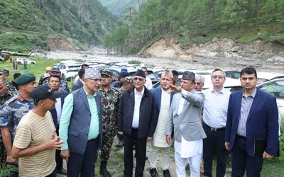
PM inspects flood-hit area
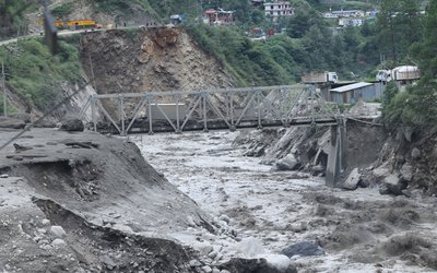
Prime Minister KP Sharma Oli has returned after conducting an on-site inspection of the flood damage in the Bhotekoshi River in Rasuwa.
During his visit on Tuesday afternoon, he discussed the damage, rescue, and relief efforts with local authorities, elected officials, and residents. Concern was expressed over the missing individuals in the affected areas, the damage to the dry port at the Rasuwagadhi customs point on the Nepal-China border, and the loss of cargo containers swept away. The Prime Minister's secretariat reported these details.
With rising temperatures increasing the risk of glacial lake outburst floods (GLOF) and extreme rainfall, there is a likelihood of significant floods and damage to roads and other infrastructure in Nepalese rivers. To mitigate potential damage, Nepal should establish a mechanism with China to share information.

Keshab Poudel
Poudel is the editor of New Spotlight Magazine.
- LIEUTENANT COLONEL JP CROSS: Centenary Birthday
- Aug 06, 2025
- Israeli Officials Say That 20 People Including Bipin Joshi Are Alive
- Aug 05, 2025
- ERC Nepal Is Focused On Expanding Distribution And Transmission To The Private Sector: ERC Chair Dr. Dhital
- Jul 06, 2025
- FOURTH PROFESSOR Y.N. KHANAL LECTURE: Nepal-China Relations
- Jun 23, 2025
- Colonel JP CROSS: Centenary Birthday
- Jun 23, 2025