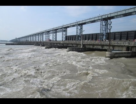
The greatest advantage of the Kosi Canal Waterway would be its suitability for operation of relatively big river vessels that can connect future river port in Nepal with other neighbouring coastal seaports also located far away from the Haldia seaport, which is at the terminus of the Hooghly river. This type of sea-river shipping is prevalent in Europe and other countries. The load for transportation must be at least about 1000 ton. The strong advantage of sea-river shipping is found in its unique connectivity.
Seaport transshipment is not required for sea-river vessels to be able to connect the hinterland with overseas destinations. This results in lower transport costs and reduced risk of damage on account of the absence of additional transshipment. In our case the storage of goods at Haldia or Calcutta port could be avoided. Few cases of sea-river vessels operation in Europe are as follows.
Country Canal/ River Draught Air Draught Tonnage
Finland Saima canal 4.3 m 24.5 m Tonnage 2,000/2500
France Rhone 3 m 5.1 m Tonnage 1,000/1,500
Netherlands Juliana Canal 3 m 6.8 m Tonnage 1,000/1,500
German Upper Rheine Canal 2.5 m 6.8 m Tonnage 1,000/1,500
Advantages of Kosi Canal Waterway
The use of the Kosi canal for navigation instead of the natural river course would allow Nepal to develop this very important waterway on a par with the waterways that exist in Europe and America that would be suitable for operation of river/sea vessels. Some of the major advantages of the canal waterway linking Chatra with Kursella where Kosi merges with the Ganges are described below:
Short Distance - The navigation canal would follow the shortest route to the Ganges river. The length of the Kosi navigation canal from the Indo-Nepal border near Birpur to the Ganges is expected to be only about 150 km, whereas the length of the river route to cover the same stretch is about 270 km.
Decrease in Water Losses - Withdrawal of water from the river for irrigation or other purposes would have to be significantly restricted to maintain adequate depths if the natural river channel is to be used for navigation. In case of the navigation canal, the water requirement to maintain adequate depths would be very small. The problem of water losses in the operation of the navigation canal would not even arise if such canal is to be used as a conveyance system to deliver water for irrigation purposes.
Increased Water Depths - The entry point of the Kosi navigation canal into the Ganges is near the extreme tail end of this river. As a result, the Ganges river channel is sure to be quite deep on this stretch, allowing the operation of relatively large river vessels. Moreover, there might have already been significant improvement in navigability of the Ganges river right up to the mouth of the Kosi navigation canal into the Ganges due to increase in water depths after the completion of the Farakka Barrage. The Farakka Barrage reservoir backwater must have extended further upstream along the Ganges far beyond the mouth of the Kosi River.
Layout of the Kosi Navigation Canal
According to 1997 Kosi Study Agreement signed between Nepal and Indian Government a detailed study of the Kosi High Dam would be carried out along with detailed study of the navigation canal linking Chatra with the Ganges that would provide our country direct waterway access to seaport. Needless to say the proposed waterway could also be used for river-sea vessels operation.
The Kosi Navigation Canal would be linked with the India’s National Waterway No.1. This canal waterway should be planned on par with the capacities adopted for the lower reach of the Ganges. The proposed Kosi navigation canal can be divided into two reaches. They are the 45 km long upper reach between Chatra and Birpur ( near Indo-Nepal border) and the 150 km long lower reach between Birpur and Kursella on the Ganges. The Upper Reach Canal will be entirely in Nepalese territory.
Upper Reach Kosi Canal Proposed by India
It has been proposed in the Kosi High Dam Project Report prepared by the Government of India that a north-south canal will be built from Chatra to the Birpur area to deliver clear water from the Kosi storage reservoir for irrigating land in India to the east of the Kosi river. This canal would be 130m wide. There is a drop of about 40 metres between Chatra and Birpur. It is proposed in the Indian report that three powerhouses would be build along the proposed canal to utilize the topographical gradient for the generation of electricity. The capacity of each such power station is expected to be about 100 MW.
The canal proposed to be built for delivering water from Chatra to Birpur for irrigation and power generation could also be used for navigation purposes. The proposed irrigation canal is sufficiently wide for use as a navigation canal. However, the canal would require significant improvements. A navigation canal requires that adequate water depths be maintained in the canal at all places and at all times. Similarly, it would also be necessary to take into account matters related to free board, and the protection of the bank and the bottom of the proposed canal. The canal would be needing navigation locks for negotiating the fall across the powerhouses. There should be three navigation locks parallel to the powerhouse in the upper reach canal between Chatra and Birpur.
Lower Reach Kosi Canal
The Lower Reach Kosi canal would be completely in the Indian territory. The north-south slope of the land in this reach of the Kosi canal would be less steep compared to the slope of the land in the upper reach. Nonetheless there is a drop of about 40m in a north-south direction within a distance of 150 km. It might be necessary to provide 3 to 4 locks to negotiate this drop. These drops could also be used for power generation. Similarly, the navigation channel running to the Ganges could be used for delivering water for irrigation.
Size of Navigation Canal and Locks
The dimension of various structures of the Kosi navigation canal should be adopted based on the size of the Farakka locks and navigation channel. The dimensions of the navigation structures should be adequate for the operation of barges of 1,500 ton capacity.
The Indian Government proposed irrigation cum power canal between Chatra and Birpur is 130 meters wide. The width of the proposed Kosi canal exceeds the minimum size required for its use as a navigation canal. However, the width of the lower reach Kosi canal could be reduced if it is to serve exclusively for navigation. We might adopt the width of this canal somewhere in the range between 80 m and 100 m. It was the minimum width for I and II classes (topmost) navigation channels in the former USSR.. The minimum water depth in the Farakka canal is 4 meters. The same navigation depth could be adopted for the Kosi navigation canal. Farakka lock has two chambers, each 25.15 meters wide and 187.7 meters long. This dimension could also be adopted for the Kosi navigation locks. The minimum depth of water at the sill might be taken to be 3.5 meters. Such lock size would permit passage of barges upto 1,500 tons or more in capacity. It would also be necessary to adopt the filling time of the lock chambers that would determine the ultimate capacity of the waterway.
Implementation of Kosi Canal Waterway Project
Kosi Canal Waterway Project, which has great economic as well as political significance for our landlocked country, should be treated as inseparable component of the Kosi High Dam Project whenever it is decided to implement this mammoth dam project to save the life and properties of millions in North Bihar from long feared devastation resulting due to permanent change in Kosi river course during very high floods in near future as predicted by many internationally renowned experts on Kosi.
To realize the full extent of damages resulting from the future floods of the Kosi, a river known as the “Sorrow of Bihar”, we should look at the experience of China’s Yellow River, which is also known as the “Sorrow of China”. According to the article “ YELLOW RIVER: NATION’S SORROW” by XIONG LEI published in CHINA DAILY on October 16, 1998, keeping the Yellow River at bay has saved the country US$ 50 billion as a result of construction of large storage dams.
German Assistance
Very recently India’s transport minister Nitin Gadkari has visited the USA and European countries to get information on inland waterways that could be useful for India’s extensive waterway development plan. At present even France, a country pioneer in the field of canal waterways in Europe, has requested Germany to help to modernize some of its outdated navigation canals. Thus Germany could be the most appropriate country to provide technical assistance in conducting detailed study of the Kosi Canal Waterway.

Dr. A.B. Thapa
Thapa writes on water resources issue
- Dudhkosi Multipurpose Project
- Jul 11, 2022
- Dudh-Kosi Power Project And Kosi Treaty
- Sep 27, 2021
- Uttarakhand Glaciers And Recent Disaster: A Lesson To Our Country
- Mar 02, 2021
- Multipurpose Langtang After Melamchi: Inter-Basin Water Transfer
- Nov 04, 2020
- Large Storage Dams Projects Wary of Giving Away Children’s Inheritance
- Dec 22, 2019


